No. 4 Origin entry
Jigsaw Puzzle History: A 1766 Map Cut Along Its Borders
Who Decided the Inch Published
Origin card
Short answer
Spilsbury's 1766 map of Europe, cut along its borders, is the oldest jigsaw puzzle found for this page. Calling it the first is the British Library's claim, and no second, independent source for it was read.
- Name
- Jigsaw puzzle
- Category
- Playthings
- Earliest known record
- 1766 · map of Europe cut into pieces along its borders, the earliest found for this page · British Library, LondonThe earliest known record is not the same as the time or place of invention.
- Origin attribution
- Unknown: the British Library's description says Spilsbury's 1766 puzzle is believed to be the first purpose-made one; no second, independent source was read for this page
- Key document
- Europe divided into its kingdoms &c., J. Spilsbury, London, 1766 page scan; British Library description on its Commons file page editor's abstract; York Castle Museum description of a second Spilsbury puzzle editor's abstract; Edgeworth, Practical Education, 1815 printing full text
- Still in use?
- Yes: jigsaw puzzles are still made and sold (as of 2026)
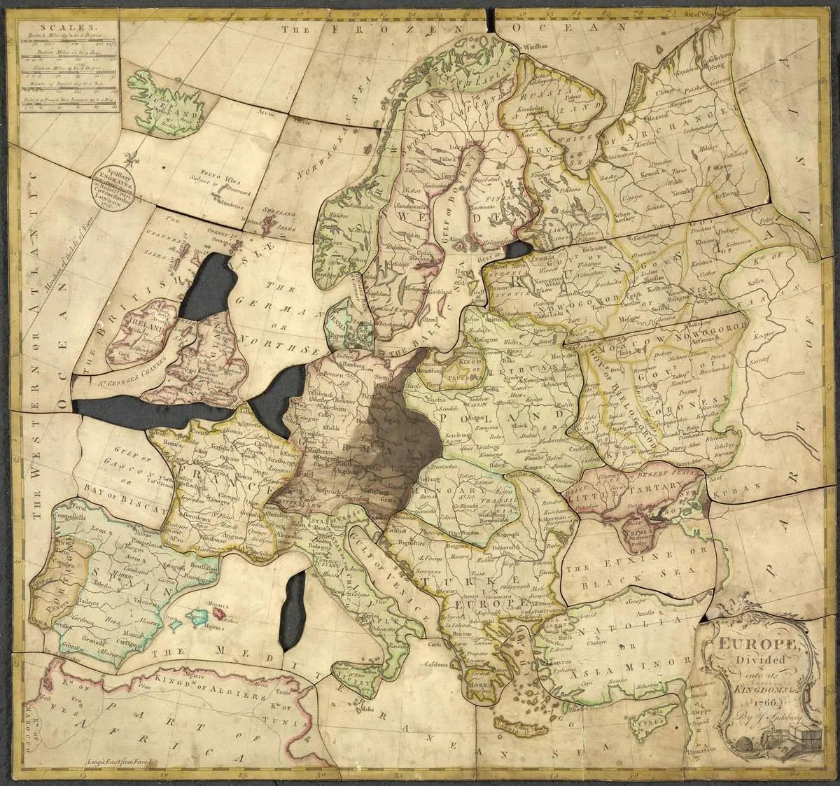
A map of Europe signed by J. Spilsbury and dated 1766, cut along its borders; the dark gaps are missing pieces.
"Europe divided into its kingdoms &c., by J. Spilsbury, 1766" by John Spilsbury, British Library — https://commons.wikimedia.org/wiki/File:Spilsbury_jigsaw_-_John_Spilsbury,_1766_-_BL.jpg — CC0 1.0 (https://creativecommons.org/publicdomain/zero/1.0/); modified: resized from 1,434 x 1,342 to 1,200 x 1,123 px
Turn a jigsaw piece over and look at the bare cardboard on its back. Nothing on that plain side says a puzzle has to be a picture, and the oldest one found for this page is a map.
The map shows Europe, and it is dated 1766 and signed by J. Spilsbury, an engraver and map seller in London page scan. Its pieces follow the borders of its countries. The British Library, which holds it, claims in its description that the map was pasted onto board and that the puzzle is “believed to be the first purpose made jigsaw puzzle” editor's abstract. No second, independent record of that claim was read for this page, so the puzzle stands here as the earliest example found, not a proven first.
What does the 1766 puzzle show?
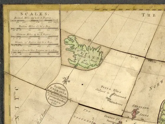
The top left corner of the 1766 puzzle, with its box of scales, the piece for Iceland and the engraver's round label out in the Atlantic.
"Europe divided into its kingdoms &c., by J. Spilsbury, 1766 (detail)" by John Spilsbury, British Library — https://commons.wikimedia.org/wiki/File:Spilsbury_jigsaw_-_John_Spilsbury,_1766_-_BL.jpg — CC0 1.0 (https://creativecommons.org/publicdomain/zero/1.0/); modified: cropped to the top left corner, box 0,0 to 560,420 in pixels of the 1,434 x 1,342 original
The British Library puzzle names its own maker twice. A decorated title panel in the lower right corner reads “Europe Divided into its Kingdoms &c. 1766. By J. Spilsbury.” A small round label out in the Atlantic adds “Spilsbury Engraver, Map & Print Seller in Russel Court, Covent Garden, London, 1766.” Between them, the two labels record a man who sold maps and prints, his London street address and a year.
The map is a working map, not a simplified picture. A box in the top left corner gives five scales of distance, starting with British miles at 69 1/2 to a degree and ending with British and French sea leagues. Lines of latitude and longitude run across the sea. Several of the cuts in open water follow those printed lines.
The library's description, as copied onto the puzzle's Wikimedia Commons file page, adds details that the image alone does not show editor's abstract. According to that description, the map was “pasted onto board and dissected along country boundaries to make an educational jigsaw puzzle.” It counts 50 pieces, five of them missing. It also notes that the lid of the box holds a smaller copy of the map with an incomplete handwritten label.
Who made the first jigsaw puzzle on record?
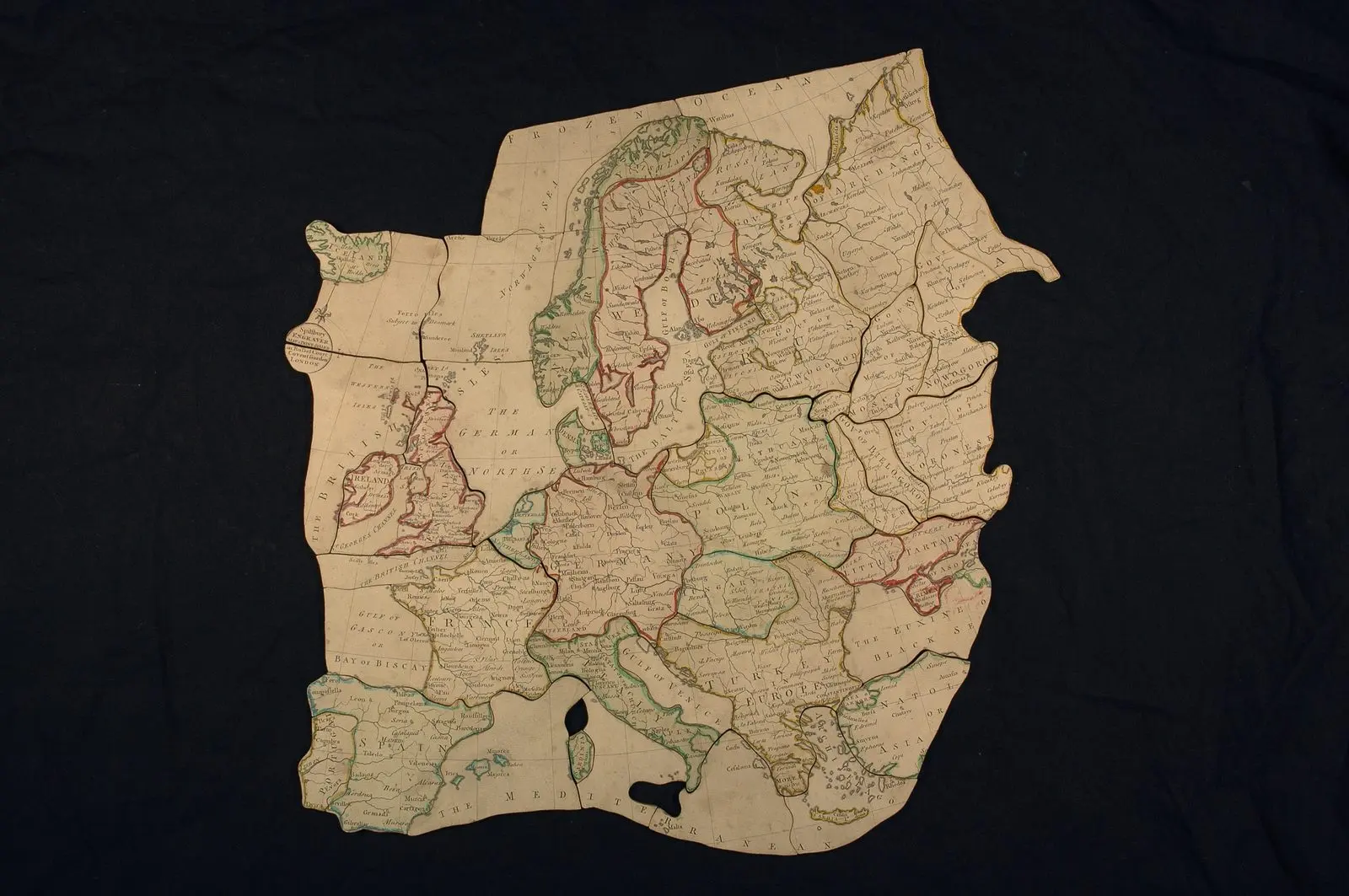
A second map puzzle of Europe, credited to John Spilsbury and dated 1766 by York Castle Museum, laid out with gaps where Sicily and Corsica belong.
"Europe Map Jigsaw, York Castle Museum YORCM AA2416" by Photographed by York Museums Trust Staff; image courtesy of York Museums Trust — https://commons.wikimedia.org/wiki/File:Europe_Map_Jigsaw_YORCM_AA2416.jpg — CC BY-SA 4.0 (https://creativecommons.org/licenses/by-sa/4.0/); modified: resized from 4,011 x 2,666 to 1,600 x 1,063 px
A second puzzle from the same maker is at York Castle Museum. According to its file page, which credits John Spilsbury as engraver and dates the puzzle to 1766, it comes in a mahogany box and has 45 pieces, with one of them, Sicily, missing editor's abstract. The photograph on the same page also shows a gap where Corsica belongs. Spilsbury's map was evidently cut more than once, and the two puzzles do not have the same number of pieces.
Neither file page gives Spilsbury's dates or says how many of his puzzles were sold. The record found for this page therefore names a maker and a year, but it cannot rank him against anyone else.
The good story
The British Library's description claims its 1766 map is “believed to be the first purpose made jigsaw puzzle.”
The paper trail
The puzzle's own labels give the maker's name and the year 1766 page scan. The claim to be first comes from the library's description editor's abstract, and no second, independent record was read for this page.
The good story
The same description calls the cut map “an educational jigsaw puzzle.”
The paper trail
The earliest account of such a toy in use found for this page, in the 1815 printing of Practical Education, treats putting a dissected map together as a contest between quick guessing and careful judgment full text. That passage says nothing about learning the names of places.
Why were the earliest puzzles on record maps?
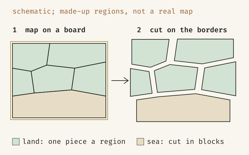
A schematic of a dissected map: the cuts follow the borders, so each land region is one piece; the regions are made up, not a real map.
Drawn from the British Library's description of the 1766 puzzle (editor's abstract) and the puzzle's own image (page scan); a schematic, not a copy of the map.
"Cutting a map along its borders: a schematic of a dissected map" by Who Decided the Inch, https://whodecidedtheinch.com/playthings/jigsaw-puzzle/, licensed under CC BY 4.0, https://creativecommons.org/licenses/by/4.0/
Data: British Library description of Spilsbury's 1766 puzzle, on its Wikimedia Commons file page
A printed map arrives with its cutting lines already drawn. On the 1766 puzzle, France and Poland each fill a single piece and Spain shares one with Portugal, while Russia is divided along the borders of its provinces. The seas and the far north, which have no borders to follow, are cut into rough blocks.
None of the sources read for this page explains why Spilsbury chose a map. The library's description calls the result educational, and the clearest early account of such a toy in use comes from a book about teaching. In the American printing of 1815, the chapter on toys in Practical Education, by Maria Edgeworth and Richard Lovell Edgeworth, opens one passage this way: “Whoever has watched children putting together a dissected map, must have been amused with the trial between Wit and Judgment.”
The book then sets a quick player against a careful one. The quick one catches instantly at a “bit of the wooden map, that has a single hook or hollow” that seems likely to fit, and “makes, perhaps, twenty different trials.” The careful one “examines with his eye the whole outline before his hand begins to move,” and in the book's telling, “He is slow, but sure, and wins the day.”
In the Edgeworths' description the pieces are wooden. The library's description of Spilsbury's map speaks of board. The Edgeworths also present the dissected map as practice in observation and judgment, and the passage says nothing about place names. Froebel gifts are another plaything tied to teaching, listed by number in a kindergarten catalog dated 1896 by its library record.
What were early jigsaw puzzles called?
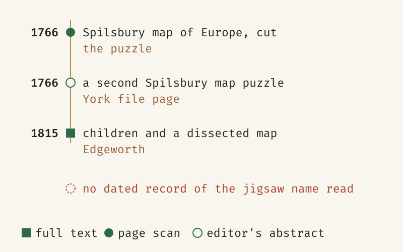
The dated records of early map puzzles found for this page, each marked by how far its source was read, from full text to an editor's abstract; neither the 1766 labels nor the 1815 book uses the jigsaw name.
Drawn from the 1766 puzzle's own labels (page scan), the York Castle Museum file page (editor's abstract) and Practical Education, vol. 1, in its 1815 American printing (full text); rows sorted by date.
"Early map puzzles in the records read for this page" by Who Decided the Inch, https://whodecidedtheinch.com/playthings/jigsaw-puzzle/, licensed under CC BY 4.0, https://creativecommons.org/licenses/by/4.0/
Data: J. Spilsbury, Europe divided into its kingdoms &c. (1766), British Library; York Castle Museum, YORCM AA2416, file page description; Maria Edgeworth and Richard Lovell Edgeworth, Practical Education, vol. 1 (1815 printing)
| Date | Maker | What the record shows | Source | Read |
|---|---|---|---|---|
| 1766 | J. Spilsbury, engraver, map and print seller, London | Europe divided into its kingdoms, a map cut into pieces along its borders | The puzzle's title panel and engraver's label, British Library | page scan |
| 1766 | John Spilsbury, engraver, as the file page gives him | A map puzzle of Europe in a mahogany box, 45 pieces, Sicily missing | York Castle Museum file page | editor's abstract |
| 1815 | Maria and Richard Lovell Edgeworth | Children putting together a dissected map, with pieces of a wooden map | Practical Education, vol. 1, chapter on toys | full text |
The table as data (CSV, jigsaw-timeline.csv) (source and license notes) Data: J. Spilsbury, Europe divided into its kingdoms &c. (1766), British Library; York Castle Museum, YORCM AA2416, file page description; Maria Edgeworth and Richard Lovell Edgeworth, Practical Education, vol. 1 (1815 printing)
In the 1815 printing, the toy is called “a dissected map,” and its pieces are bits of “the wooden map.” The library's description, as given on the file page, also uses the word dissected, but it is a modern description rather than a period record. The yo-yo is another toy with older names than its own in the records read for it.
No dated record of the jigsaw name could be read for this page, so when the puzzles took that name is unknown here. So is the moment when pictures began to replace maps.
Spilsbury's prices, his customers and his dates were not found either. Earlier editions of Practical Education were not read. No other early maker's work could be checked. A readable advertisement, trade catalog or dictionary entry from those years would change this entry.
Sources
- J. Spilsbury, Europe divided into its kingdoms &c. (London, 1766), map of Europe cut into pieces along its borders; British Library, Maps.188.v.12; image as given on its Wikimedia Commons file page. Image released by the British Library under CC0 1.0. commons.wikimedia.org/wiki/File:Spilsbury_jigsaw_-_John…How far it was read: page scan; the puzzle's own title panel, engraver's label and scale box, read from the library's image
- British Library, description of Spilsbury jigsaw (Europe divided into its kingdoms &c., by J. Spilsbury, London, 1766), on its Wikimedia Commons file page. commons.wikimedia.org/wiki/File:Spilsbury_jigsaw_-_John…How far it was read: editor's abstract; the library's description as copied onto the file page
- York Castle Museum (York Museums Trust), Europe Map Jigsaw, YORCM AA2416; photograph and description as given on its Wikimedia Commons file page (CC BY-SA 4.0). commons.wikimedia.org/wiki/File:Europe_Map_Jigsaw_YORCM…How far it was read: editor's abstract; the museum's description as given on the file page, with the photograph viewed
- Maria Edgeworth and Richard Lovell Edgeworth, Practical Education, vol. 1, second American edition (Providence: J. Francis Lippitt; Boston: T. B. Wait & Sons, 1815). Project Gutenberg ebook 28708. Public domain (EU: authors d. 1849 and 1817, per Project Gutenberg catalog record; US: published 1815). www.gutenberg.org/ebooks/28708How far it was read: full text; vol. 1, chapter I, Toys


Cite this page
Who Decided the Inch. “Jigsaw Puzzle History: A 1766 Map Cut Along Its Borders.” Published November 22, 2026. https://whodecidedtheinch.com/playthings/jigsaw-puzzle/. Accessed on the day you read it.
- To the original: how sources are read
- Marked in the margin: every correction
- Report an error on this page (contact@whodecidedtheinch.com)
Related entries
Teddy Bear History: From a Cartoon Cub to 1907 Book Titles
Picture credit
"Drawing the Line in Mississippi, by Clifford K. Berryman, 1902" by Clifford K. Berryman — https://commons.wikimedia.org/wiki/File:Drawing_the_line_in_Mississippi_LCCN2008678324.jpg — Public domain (EU: Clifford K. Berryman died 1949 (per library catalog record, as given on the file page), more than 70 years ago (life plus 70 years); US: published before 1931 (1902); marked Public Domain Mark 1.0 on the file page)
Yo-Yo History: In the Records Read, the Toy Had Other Names
Picture credit
"A woman playing with an early form of the yo-yo, fashion plate, 1791" by Unknown artist — https://commons.wikimedia.org/wiki/File:1791-Yo-Yo-Bandalore.jpg — Public domain (EU: anonymous fashion plate, first published in 1791 (per the file page), more than 70 years ago (70 years from publication); US: published before 1931; marked Public Domain Mark 1.0 on the file page); modified: cropped: the bottom 37 pixels of the plate removed (full width kept, 492 x 806 from 492 x 843)
 Illustration
Froebel Gifts: A Ball, a Cube, Then Blocks Cut Into Parts
Illustration credit
Illustration: Who Decided the Inch. Generated schematic image — not a photograph or historical record. No copyright is claimed in this generated illustration; if you reuse it, please keep this label.